https://shirecraft.us/forum/uploads/092/D7OODNKY1ZTX.png
So the Central Station of Frankrikeshavn opened. For anyone who has shopping chains through The Shire : there are shopping spaces in the station for you. Here's what the opened sections look like right now.
EDIT : Thanks a lot Andy ! He set up an STA ticket office and a Costa Copy. So no more shopping spaces available.
Vi ses snart i Frankrikeshavn, Norks222.
Frankrikeshavn
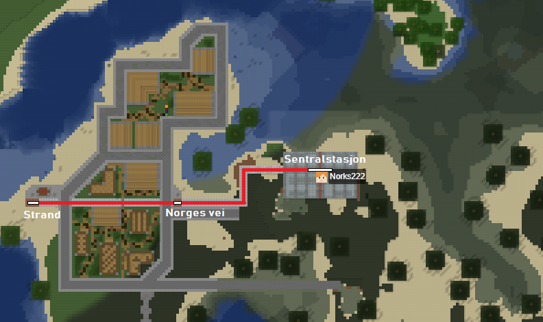
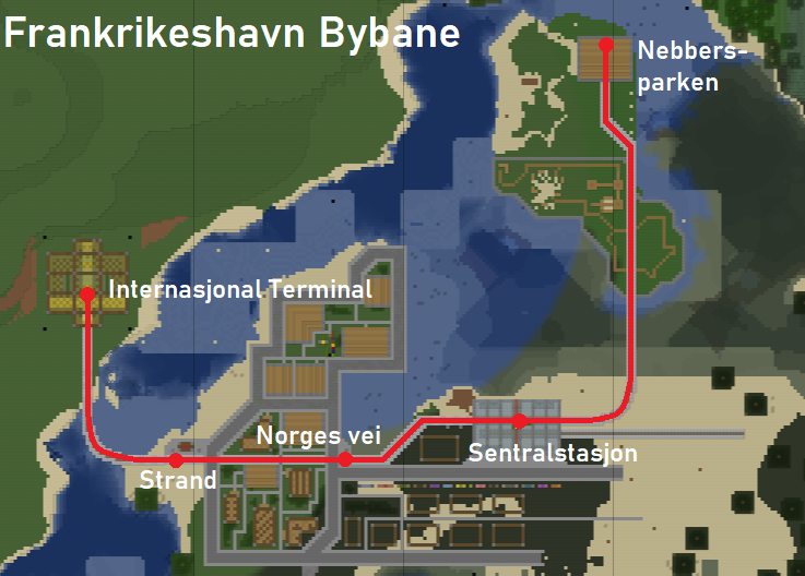
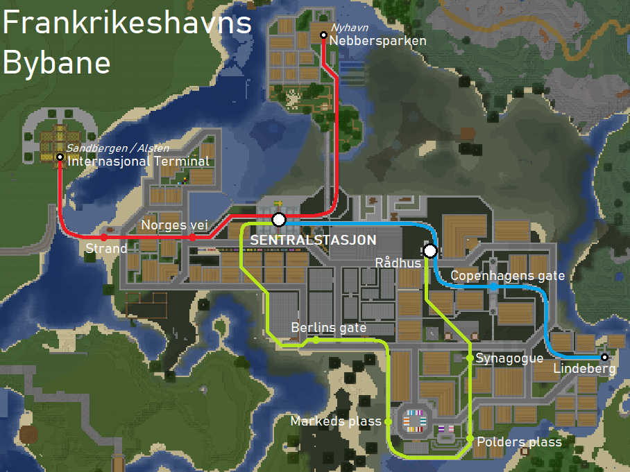
Just a map of what's going to be developed for neighbors and curious people.
There will be three streetcar lines (sometimes at street level, sometimes underground) as shown on the map.
There might be an extension of the Red Line towards the other side of the river for an eventual connection with the main STA Railway Network, due to lack of space on the island for a railway.
All lines will generally have simple infrastructure : single-track and 3-block right-of-way to save space, and 3x3 large tunnels. All lines will use tunnels to go under the sea, except for the Red Line from the Beach Resort to the other side of the river due to lack of space on the Beach Resort.
Other specific locations are indicated on the map.
Comments
-
Cool! looks like it's going to be pretty nice, can't wait to explore it when it's done
1 -
Hello,
Due to lack of space for a tunnel portal on the Red Line, the plans are a little changed for the lines.
The Customs main building won't be build directly near the shore, but in front of a viaduct for the Blue Line and not behind it - the original plan was for the Blue Line to directly under a tunnel and the Customs building over it. The terminus will still approximately be at the same place, although it won't be an underground station as planned but and elevated stations with a little space for shops.
This also means the Red Line will not cross the sea by a tunnel, but by a viaduct.
Vi ses snart i Frankrikeshavn, Norks222.
-1 -
This is most unfortunate news. However, I concede it sounds like it is for the best. Godspeed, Norks.
1 -
So the Central Station of Frankrikeshavn opened. For anyone who has shopping chains through The Shire : there are shopping spaces in the station for you. Here's what the opened sections look like right now.
EDIT : Thanks a lot Andy ! He set up an STA ticket office and a Costa Copy. So no more shopping spaces available.
Vi ses snart i Frankrikeshavn, Norks222.
Post edited by Narcs121 on0 -
Costa Copy takeover! 👀
How's the new island going?
0 -
Hey,
First, Andy, it's going well ! If you're watching this on 19/09 I finished building the park, in honour of @nebbers who helped me a lot when I first joined the server and also after when I was unbanned.
Right now the Red Line has entirely opened, apart from a section, which I hesitate to build right now as there are more important things, that was meant to go on the "mainland" as there isn't space for a real STA station in Frankrikeshavn. It's going all the way from Strand to Nebbersparken, serving Norges Vei and Sentralstasjon.
The priority, after I finish Nyhavn Island, is on the Town Hall and Customs with the Blue Line to the Town Hall, then to the shopping zone and the Green Line to the west (not immediately Englands Island).
0 -
Finished the STA station of Frankrikeshavn. Now it only needs to be connected to the STA railway network. The Red Line has been extended to the terminal itself by now. It's got a nice canopy and 2012 architecture, by the way.
0 -
Almost finished the customs, and began the commercial zone. Although I do already have a WaitroseCopy, I think i'll need some other shops by then, when i'll have finished the zone.
0 -
If you need restaurants, I can drop a falafel shop in there0
-
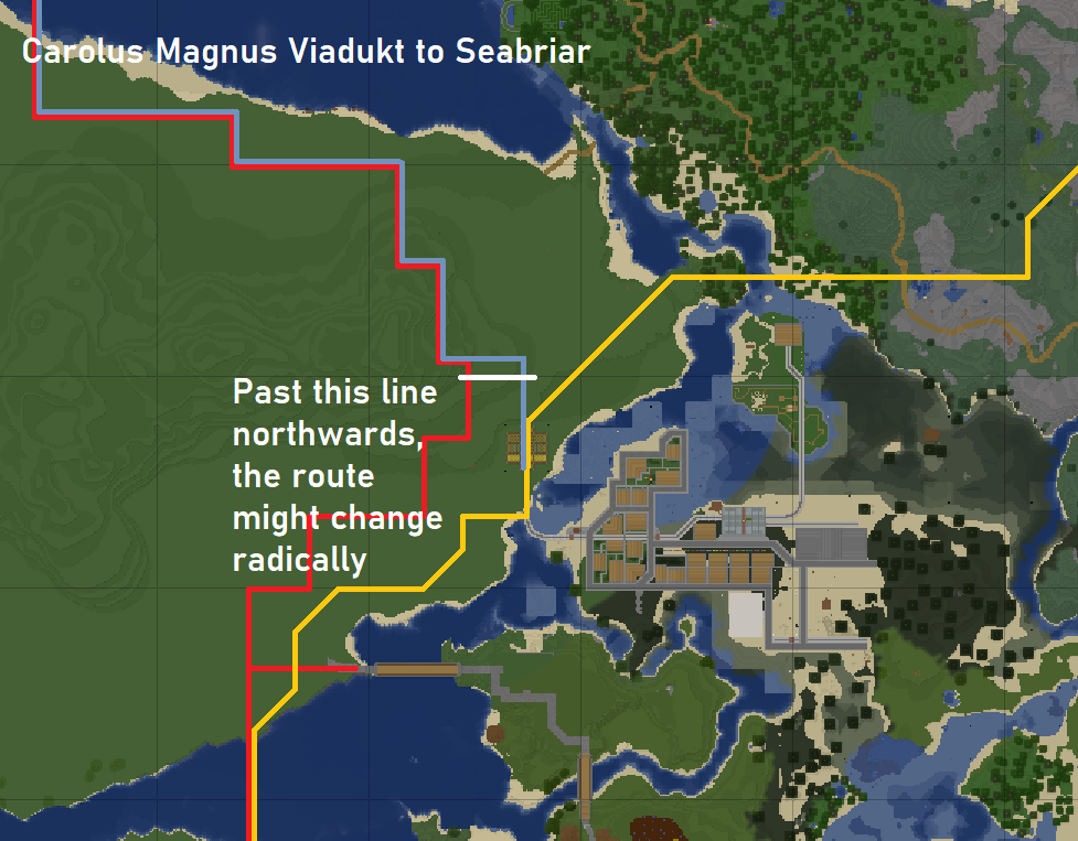
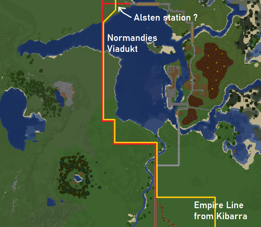
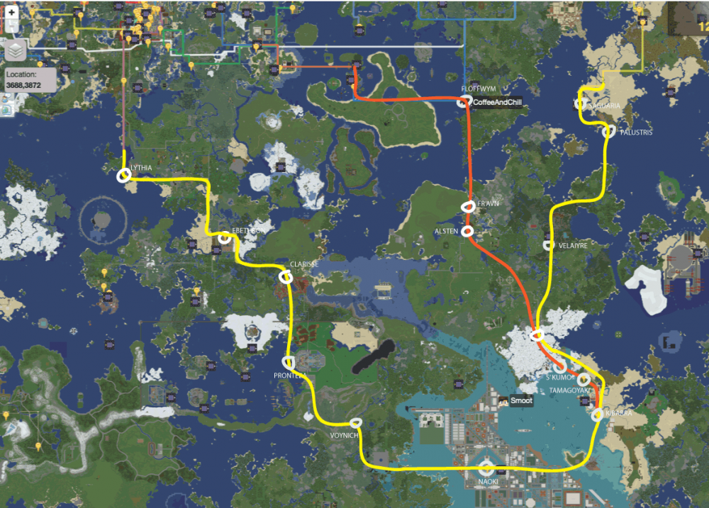
So here I've developed plans for a highway from the existing one to Kibarra and for the Empire Line. I could build the infrastructure on 1st and 2nd pictures myself. Red lines represent a highway that should be created / enlargened, golden lines represent the Empire Line and cyan lines represent an eventual extension of the Skira Line from Reeder. Because of this eventual extension, I might have to rebuild the International Terminal, just in case. I might - and actually will - build a big city right next to the International Terminal, but it will be in a separate region. Because it will be very big, I think they would be demand for a Skira line extension to it.
0 -
This is what I'm working from at the moment, with your station on the Thule line. Skira was only meant to serve some small communities - I won't extend it that far. :-( We can look at adding a new Empire line branch to serve your project, potentially Clarisse - ? - Frankrikeshavn - Velaiyre? Or could make the Thule line split, so at your station there is another branch created that goes west and through Clarisse.
0 -
Well, it could seem weird but I have plans for many projects - including one a few hundred blocks east of Floffwym. So I wanted to have served by the Thule line towards Saguaria, but I can't have it all - Frankrikeshavn and that project.
Although we could find common ground, I wanted for the Empire Line to serve Frankrikeshavn, and not the Thule, for a simple reason. The Thule would've lost the stop at Saguaria. You're gonna tell me - why is it important ? Who cares ? Well, a stop at Saguaria would've allowed a quicker way to go from Mainland, and actually most important places on the Shire, to all projects between Saguaria and Emerald City. The Thule Line not stopping at a few places makes it far quicker than the Quintus. It would also be at the advantage of Palustris and Velaiyre - otherwise, they are really isolated.
Also - my first plan for a station at Frankrikeshavn was for a Skira Line extension. I've given up that plan since long ago. But yet I'm building a station in Frankrikeshavn for 2 lines solely in prevision of it. But I'll be clear, the Skira Line wouldn't - and even shouldn't be extended past Reeder until 3 things :
- the project I've talked about becomes consequent in size ;
- the Empire Line is open from Sunspear to Emerald City ;
- the branch to Elathuria Island isn't built.
Shortly, it'll take a long time before it'll have to be extended.
0 -
I found old plans for the Empire Line.
https://wiki.shirecraft.us/images/archive/4/4e/20180106175239%21Shire_Railway_Map_2018.png
I mean, the original plan was to have the Empire Line at Alsten, then Floffwym and Saguaria.
0 -
That was before people moved projects around in that region. Floffwym is too small for 3 lines
0 -
Yeah, I know and if we have the Thule at Floffwym and Saguaria it'd be useless to have the Empire too. I was saying that the original plan was, in fact, to pass by Alsten. Back in these days, I hadn't even joined the server once, though.
By then, Naoki has been moved so of course the route had to be changed. But IMO, having a direct line between Kibarra and Saguaria is useless when it can be more useful by serving other communities.
If I want the Empire Line there, it's because I think it's way more important to have a direct link to Venezia, especially for interchanges, than a direct link to Mainland. Especially since there's the Franco at Rabblegard, where everyone can have even quicker interchanges in Venezia. The Empire will also be in Fulfwotz and Pitfall, and that could give much quicker access to West Shire.
0 -
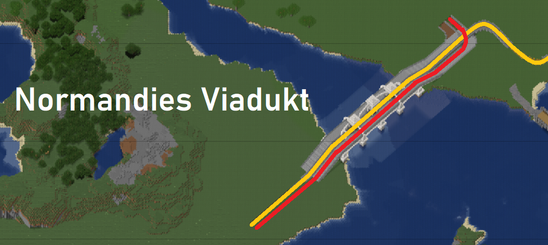
Thanks to @Smoot for the inspiration and to @CoffeeAndChill for some help later on about it, I finished building Normandies Viadukt, named in honour of Normandy, a region in France that was once colonized by the Vikings.
It's one step further in the connection between Frankrikeshavn and the southeastern Shire - Kibarra, Naoki, etc.
[img]https://zupimages.net/up/19/45/drrj.png[/img]
1 -
So, thanks to @Smoot for the inspiration and to @CoffeeAndChill for some work on it later on, I finished building Normandies Viadukt, in honour of Normandy, a region in France once colonized by the Vikings.
This is one step further to the connection of Frankrikeshavn to southeastern Shire - Kibarra and Naoki in particular.
1 -
It looks really nice!
1 -
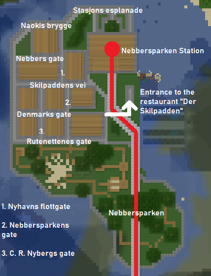
Day by day, the work is going on, and day by day, the town gets bigger and more enjoyable to explore. Infinitely more. In some 2 days I managed to build what is probably Frankrikeshavn's "cutest" part thanks to its charm of a little village.
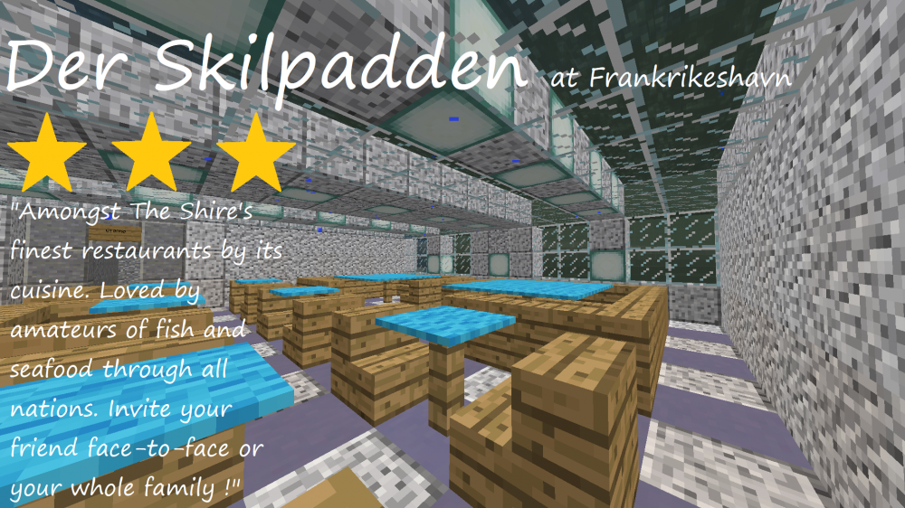
I've also build something that was not planned at all, and was planned only in the day - a underwater restaurant named "Der Skilpadden", for those who don't understand Norwegian, which means most of people reading this, "The Sea Turtle". You shouldn't forget to dine at it.
Nebbersparken which was at first a bit of a bland, charmless place had trees planted, some groves here and there, and a safer playground for y'all children.
As a reminder - "gate" means street, "brygge" means quay and "flottgate" is the equivalent of "high street" although I'm not really sure on this one because of the skills I really lack in Norwegian.
0 -
I don't know how the posters of news channels, cities, etc are done, but if it's done by a picture, then here I go. The picture may not be of optimal quality but it was just as a demonstration of what it could look like IMO.
3 -
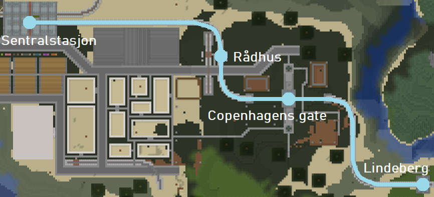
I didn't even finish the commercial zone but I didn't want to do it either. So I built some stuff around it. This stuff includes the Blå Linje (Blue Line) being officially finished in its entirety. The plans that were talked about in the first post about the islands will be cancelled as I don't have enough land, and between us, terraforming is hella boring.
All stations of the Blå Linje are finished although they would need an ID and functioning buttons to call carts (well, like on everything in terms of Frankrikeshavnian railway lines that has opened until now but...)
The foundations of a few buildings just by Copenhagens gate are already finished - they'll need foundations due to the hilly terrain. They'll also have two floors, first of all because we're in downtown Frankrikeshavn, and second because it's my town and I do whatever I want.
0 -
might i suggest renaming Nebbers Park to Sammiches822 Machine Gun Hodenplatz
4 -
what da hell is this transformation project
0 -
All buildings, be it houses or not, in the entirety of Frankrikeshavn have their structure finished by now. The project is not far from being finish, it is guaranteed to be finished by the end of February. Maybe a few days before, maybe a few days after, who knows ?
Post edited by Narcs121 on0 -
I now announce I have finished the main part of Frankrikeshavn, as all the originally planned buildings and neighbourhood now have their buildings built, although their interior is yet not furnished. This means I consider Frankrikeshavn as finished, so I can allow myself to start another project now.
0 -
That's great!! Congratulations
1 -
At the exception of the section from Berlins gate to Sentralstasjon (despite it being shown on the map), all sections of the Municipal Railways of Frankrikeshavn are opened. Only one section runs outside of Frankrikeshavn : it's the Røde linje (Red line) west of Strand, the terminus of the line being located in another (future !) city.
8 -
So, although it's done since some 2 or 3 days, I consider all of Frankrikeshavn is finished - for now ! Although I don't feel like it, I could totally make an extension of it.
So, to sum up everything : Frankrikeshavn has two markets (one south of town and another in Nyhavn), three harbours, a church, a synagogue, a cemetery, a commercial zone, a customs building, three light rail lines with their twelve stations, a hotel, a beach resort, and two watching towers, one of them even reaching Y 106 !
I want to thank everyone who contributed even a very little to this project :
@CoffeeAndChill for the railways' buttons, station IDs, etc
@nebbers for having regioned it and set a warp
Robert09wils for the Customs building's clock
@Zhenya for the Green Line's underground station at Sentralstasjon the pedestrian bridge to Nebbersparken and the garden next to it
Master_Chief for having changed the biome's grass colour (grass was really ugly)
1 -
Congratulations!!! I'll have to come on soon and explore
0


