


New east-west line proposal

Comments
-
I would like to make a suggestion for a new line/extension or branch of an existing line. The Shire doesn’t have any reliable east west lines, so I think a potential extension of Hestia west past Brandywine West connecting it with the Juris/ Cerelia lines would be useful, it could also be extended east past Hyrule to Emerald City. Right now the only lines connecting east to west are the Aether and Cerelia in the north, but a line further south like I suggested would be a good connection.0
-
I recall there being a project of an extension from Brandywine West to Bree, that I agree to build the tunnel for if it's still planned, but I don't know if it's really useful to have another link than the Aether. Nevertheless, if this project is accepted, it should go by Covid Village (no joke, it's really named like this lol), Bastarsports, Darkensaga and Elmswell.
0 -
Right now if you want to get to, say, Fulfwotz from New Vashon, you have to go all the way up to Karaam/Arcadia and then all the way back down to Fulfwotz. An east/west line bisecting further south could cut travel time in half, not to mention service new areas as mentioned.0
-
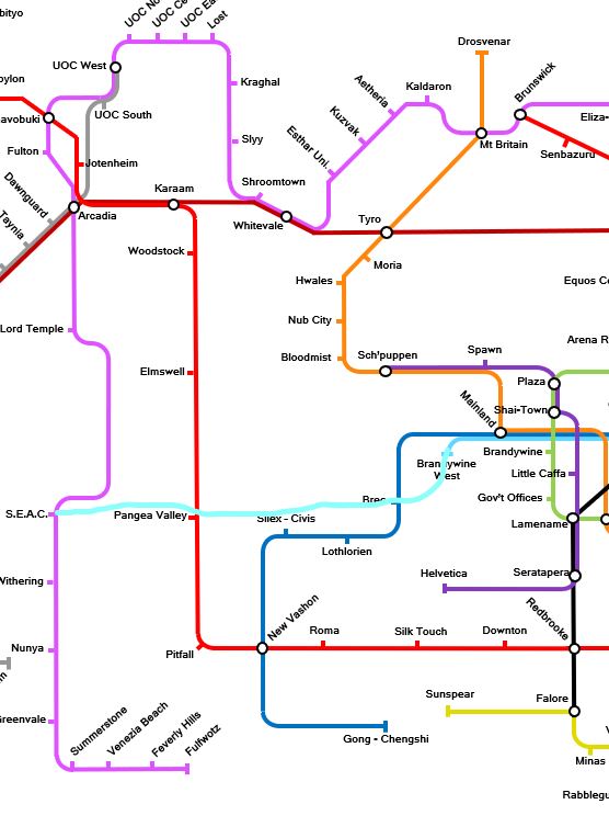
Could look roughly like that.
As you can see to travel those parts of the Juris/Cerelia requires a large detour. I think this route would be very useful. I know there are more pressing projects right now but I think this would be a very practical expansion of the railway network.
0 -
I was wondering, what software did you use to make that map @Alexander987 ? I was thinking I could use the same software or my town's metro system
Post edited by OtrementalFlameS on0 -
Just a simple powerpoint document.0
-
oh, okay
0 -
If you’re looking for something to make a map, this is one of the most useful tools I’ve found:
0 -
It looks a bit like this though : https://beno.uk/metromapcreator/
0 -
This is what I made using twintubes (link in my previous comment). This was in 2016; it's unfinished, and will be missing more recent stations like 'New Brumley'.
0 -
@Alexander987 Could go from Brandywine West to join up with the track between Bree and Lothlorien, don't stop at Lothlorien or Silex-Civis, then split off after Silex-Civis and continue West to Pangea Valley.
After stopping at Pangea Valley, continue going West to merge with the Cerelia line. Head south, skip SEAC, stop at Withering. Continue going south, skip Nunya station, stop at (new) Castle Argh station, then can head West towards Sol and join up with an existing line that goes East-West within Sol.
0 -
Honestly, a direct line to Sol would be a good thing. We already have the Aether in the North.
3 -
Also, adobe illustrator looks like a good tool to use, only problem is that it costs approx. £20 a month to use it. I might use that to make a map for my town's metro system.
0 -
This is pretty much what I had in mind.
0 -
When I first joined The Shire, I saw this discussion and thought it very interesting. As I was doing research on my Stafford Line proposal, I was also doing some research on which lines would work best as east-west lines in the south. I found two lines that would make good candidates to go west to larger builds such as Sol, and in the future, my own city of Portsmouth, also connecting to the Cerelia and Juris lines as well as the West Shire Rail:
Franco: This might seem a bit surprising, but I actually think Franco could work quite well as a connector from Venice to the southwest Shire, especially if Portsmouth goes as planned and becomes a large enough city to warrant rail connection. In addition, there are some other builds that could be connected to the rest of The Shire by rail through this potential western extension of Franco. This extension could also make Franco a more important line, as nebbers said in the Tunnel Tracker that "Franco is primarily a rail line in theory only".
Hestia: A proposal for Hestia to be extended west and potentially east as well has already been made in this discussion, and I think it is a very solid proposal, especially considering that it would make travel time to Sol, one of the largest cities in The Shire, much shorter, and also connect many locations just outside the Mainland to the railway, such as the previously mentioned Covid Village, Darkensaga, and Bastar's Sports Complex, among other locations.
I'd also like to give an honorable mention to Dulcia, which could potentially link up with the line segment going from Naoki to Pur in the south and maybe also serve as an east-west line in the northwest-central Shire, but it doesn't really fit the needs outlined here, especially considering that it, as of now, is a defined north-south line.
Once I found that Hestia and Franco would probably be the best choices to expand east or west, I decided to make some sample railway maps similar to my proposal of the Stafford Line a few months ago. These extensions aren't official proposals, just me throwing around ideas, but I do think that these extensions would be very intuitive for Shire travel. In an additional three posts (maybe four if I need them) in this thread, I will cover three potential extensions: a western extension of Franco, a western extension of Hestia, and a very, very wacky eastern extension of Hestia.
0 -
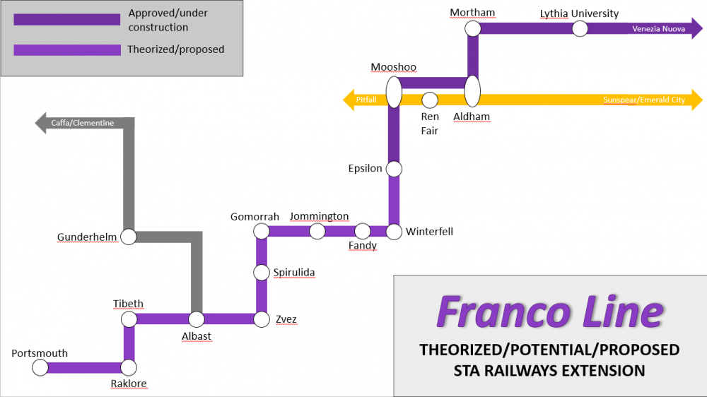
I'll start with Franco. Right now, the line only runs from Venice to Lythia University, with an extension to Epsilon approved but seemingly not under construction as of this time. Even though this map starts at Lythia University, I will start at Epsilon, as it is currently the western terminus for the whole plan of the line thus far.
From Epsilon, Franco could go to locations such as Faolan and even DesertWorld to the west, but to keep the line as fluid as possible, I chose to make the next stop on the line Winterfell. Winterfell is a town in the western part of what is known as the Gaya Alliance, which only currently has one railway station - Prontera on the Empire Line, in its eastern region. A potential Franco station at Winterfell would allow the Gaya Alliance to have connections to the railway in the east and west.
From there, I have Franco linking up with the already existing "line" going from Fandy to Gomorrah, as there does not seem to be any plan to connect this segment with other lines, and it would make potential construction of the line easier. From this segment, Franco could stop at a couple of other locations, such as Grib or Shireboyle, but I chose not to include them for being a bit far off the defined path of the line. Franco would then stop at the towns of Spirulida and Zvez before stopping at Albast, the southern terminus of the West Shire Rail. This station would connect Franco to the West Shire Rail, and thus the rest of the western Shire by rail.
After Albast, Franco would stop at the town of Tibeth before going inland again. The line could also stop at locations such as Bard's Banner Factory, the Enderp Maven Sanctuary, and the town of Entri, but I decided not to include them due to being a bit off the general path of the line. The next and penultimate stop of this western extension of the Franco line would be in the town of Raklore.
Franco would then go west again towards the currently nonexistent but soon to exist city of Portsmouth, potentially stopping at the Venetian territorial town of Diarmuid (I chose to leave it off due to it being somewhat off the path as well) before ending in Portsmouth.
0 -
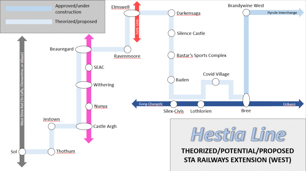
Now, Hestia is by far the more complex of the two line extensions I laid out - all of my Hestia sample maps together (the west extension and the two-part east extension) add a whopping 40 stations to the line! Before anyone reacts, though, let me talk through these maps and how they can help with the east-west line situation. So, Hestia currently goes from Brandywine West to the Hyrule Interchange, servicing 15 different locations. An extension from Brandywine West to Bree was approved at one point and is still shown to be in progress on the official railway map, and Bree is where we begin the western extension.
The western extension closely follows that suggested by @CoffeeAndChill, @Alexander987, and @Narcs121. The first stop after Bree to the west is the ironically named Covid Village (which also needs a steward if anyone wants to take care of it; more info here: https://shirecraft.us/forum/discussion/3295/covid-village-stewardship-available#latest). After stopping at Covid Village, Hestia merges with Quintus for its stations at Silex-Civis and Lothlorien, Hestia stopping at neither. Right after the Silex-Civis station, Hestia separates from Quintus and goes north on its own.
Going north, Hestia stops at Baden and Bastar's Sports Complex, before turning left towards Silence Castle. It is also possible that it could stop at Tanagra Castle, but I ultimately chose not to include it on this map due to its close proximity to@Alexander987 Baden and the sports complex. After stopping at Silence Castle and Darkensaga, Hestia could intersect the Juris line at one of two stations: Elmswell and Pangea Valley, the two most suggested Hestia-Juris intersections.
If Hestia were to go to Elmswell (included on the map), it would go straight to Elmswell, but if it were to go to Pangea, it could stop at the communities of Podesta and Brumley (not to be confused with NEW Brumley). From Elmswell, Hestia would stop at Ravenmoore before intersecting and later merging with the Cerelia line at Beauregard, under the assumption that Cerelia will get a station at Beauregard. If Hestia intersected with Pangea instead of Elmswell, the stops at Ravenmoore and Beauregard would probably be omitted and it would merge with Cerelia somewhere between Beauregard and SEAC.
Merged with Cerelia, Hestia does not stop at SEAC, stops at Withering, does not stop at Nunya, and does stop at Castle Argh (omitting potential separation to stop at locations such as Groundflower, Blackwall, Covfefe, Gaan's Military Encampment, and that stadium randomly placed west of Nunya) before separating from Cerelia and going west, stopping at Jestown and Thothum.
From Thothum, what I have laid out is that the West Shire Rail section from Sol to Thothum is just relabeled as the Hestia line, and the stations of Thothum, Sol East, Sol Central, and Sol North remain the same, the last of which being the western terminus of this extension.
At Sol North, Hestia could just turn into the West Shire Rail segment from Sol to Clementine and nothing changes on that segment, a new junction could be created at the Sol North station to separate the segment of WSR becoming Hestia from the one that is not, or the whole section of the West Shire Rail from Sol North to Clementine could also be relabeled as Hestia, and thus Hestia is potentially extended to Clementine.
0 -
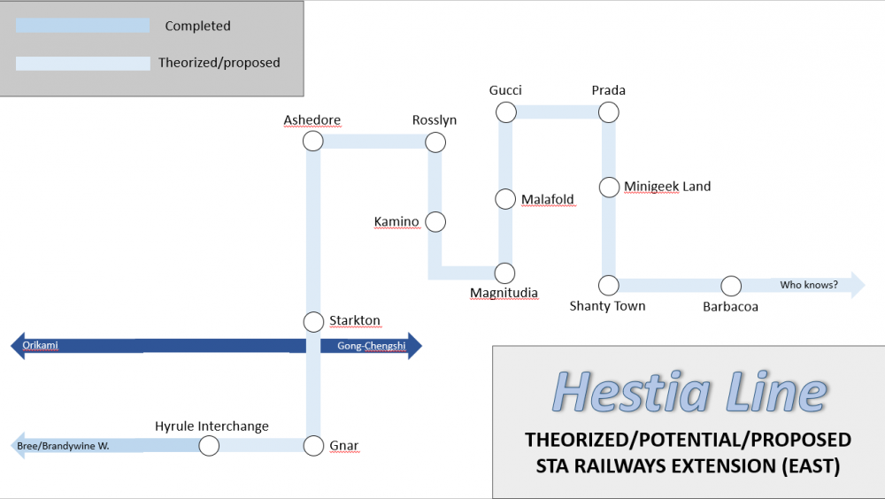
Alas, we arrive at the most insane and wacky of the extensions I laid out - the east Hestia extension. Prior eastern extension proposals favored that it would be extended directly to Emerald City, but I don't personally feel that it is needed as two well-connected lines already stop there: the Quintus and Empire lines. For my own theorized eastern extension, I favored the idea of Hestia going slightly northeast to begin, servicing locations on a strip of land not serviced by the Quintus or Nysa lines south or north of it.
From the Hyrule Interchange, Hestia would stop at the island of Gnar before heading north, stopping at the town of Starkton (and possibly a seemingly unnamed, in progress island build west of Storm Ends if it is not already planned to be serviced by Quintus) before heading back into a body of water, stopping in the underwater town of Ashedore and the Acadie-owned island of Rosslyn.
From Rosslyn, Hestia goes south, stopping in Kamino and Magnitudia before heading northeast, stopping at the Malafold Estate, Gucci, and Prada before going back south and stopping at Minigeek Land and Shanty Town. Other potential stops that I didn't include would include Wool Harbor, the Stormlands, and the ironically named Fort Hestia. The Hestia line's next stop is Barbacoa, and it is at Barbacoa where there are once again many options.
Hestia could just end at Barbacoa, or it could go south to Nagrannabaenum, Hulduholl, or Nordar and eventually join up with the Empire line and end at Emerald City (the original proposed end) or join up with the East Shire Transit and end at virtually any station between Laurelian and Treetops. Another option is for Hestia to continue and service some more areas in the northeast and meet up with EST, or to split in two and serve as a sort of "far east" line, which I will explain right now.
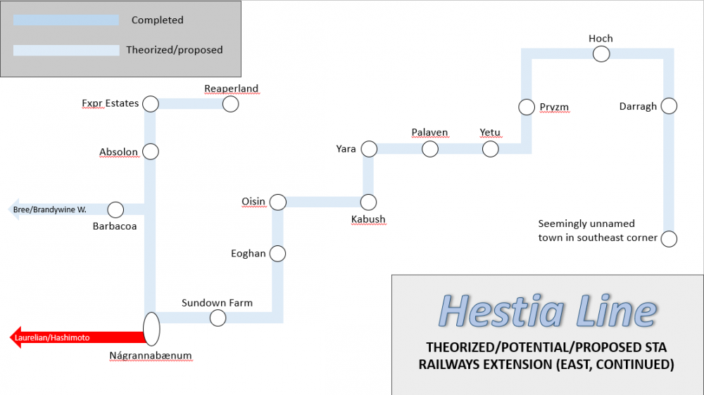
At or shortly east of Barbacoa via a Hyrule Interchange-like station, Hestia could split into a segment going northeast and a segment going southeast. Due to how connected the northeast is thanks to EST, the north "far east" Hestia segment would only have three stations: the Laurelian protectorate of Absolon, the Fxpr Estates, and Reaperland, its theorized terminus. Parts of it would also likely merge with EST, particularly on the segment between Divinity's Reach and Garth.
The southern "far east" Hestia segment is longer, stopping at four times as many stations as its northern counterpart. The first stop on this segment would be Nagrannabaenum, connecting the segment to EST and through it, other eastern lines. From Nagrannabaenum, southern "far east" Hestia would travel to the far east of The Shire, stopping at Sundown Farm along the way. From there, Hestia would travel south, briefly merging with the Empire line between Cathal and Cactus County before stopping at *DEEP BREATH* Eoghan and/or a desert town next to it, Oisin, Kabush, Yara, Palaven, Yetu, Pryzm, Hoch, Darragh, and then a seemingly unnamed town in the southeast corner of The Shire, where this segment ends.
That's all I have for these ideas, I hope you found them interesting! I feel like all of these would be fun to have in The Shire and would connect many more locations to its wonderful railway. Thank you for reading all of this!
0 -
I didn't even consider this until this morning, but an extension of Zelos might also be practical, as I believe it's tied with Franco as the shortest line at 7 stations. Unlike Franco, which covers the central-south Shire, Zelos doesn't really go outside one particular region (Mainland). Zelos also more than likely has more potential to extend east AND west, unlike Franco, as most locations that Franco could expand to in the east are already covered by other lines - in particular, Nysa, Skira, and Quintus, and if you wanted to go farther east, East Shire Transit and Empire as well. Zelos' northern terminus is farther north than Franco's, so it would probably work better as an east-west line spanning nearly the whole Shire.
To the west, Zelos could do one of two things:
- Merge with Empire to Minas, stop at Minas, go south, stopping at Timberstone, Riverside, Yorkshire, Zaphoria, Geheimnisse, DesertWorld, Faolan, and Epsilon. At Epsilon, Zelos would meet Franco, and from Epsilon, the same path taken by my earlier theorized extension of Franco (Epsilon-Portsmouth) would be taken by this theorized extension of Zelos.
- Merge with Empire west, but not all the way to Sunspear. Separate from Empire around Chowder, stop at Chowder and Grittle, go northeast, intersect with Juris at the next stop in Roma, go west, stopping at Telston, Shong-Durr, and Gray Havens. Zelos then meets Juris again between Pitfall and Saripo Cave but does not merge or have a direct intersection with it before going northwest, stopping at Bognor Regis, Covfefe, and SEAC, where Zelos intersects Cerelia. From there, Zelos goes west and then south, stopping at the Sammichian cities of Paris and Leif, before going west again and ending at either Sol North and Sol Central.
To the east, Zelos could merge with Quintus just north of Homestar Port and go east, not stopping at New Brumley, then merging with Dulcia just east of New Brumley and going north. Zelos stops at Duomo, diverges from Dulcia soon afterwards, merges with Skira, diverges from Skira just before the Range Guild station to go east and stop at Sakura. From Sakura, go north to Riverdale and stop there. From Riverdale, go north, stop at Clarksburg, merge with Juris between Rhius and Augusta Traianea, stop at the latter, separate from Juris, go north, briefly merge with Nysa going east between Whail and Rougeport, separate from Nysa, go north to Starkton and stop there, and from there Zelos just takes the same route as my prior theorized extension of Hestia (Starkton-Emerald City/Barbacoa/Nagrannabaenum/Reaperland or Seemingly Unnamed Southeast Corner Town).
This may seem a bit confusing, so if you guys would like me to make maps for this theorized Zelos extension, please let me know and I will make them!
0


